

Since the single picture taken during the inaugural 12 second flight of the Wright Flyer in 1903, imaging has been an integral element of aeronautics and, later on, astronautics. Today every aircraft flight test and space launch is carefully photo-documented. However, new technology in state-of-the-art cameras and the need for advanced aircraft flight testing have allowed photo-documentation to be expanded into scientific imaging. Fundamental aerospace design issues can be addressed by using high-quality spectral, visual, and infrared measurements. These engineering-quality data help to ensure that each flight is safer than the last.
Expanding ground-testing data
While experimental ground testing and simulations provide incredibly useful data, nothing can replicate the actual conditions of flight. With remote imagery, SCIFLI can collect data on in-flight vehicles in real-time. As project manager Jennifer Inman states, “We close the gap between ground testing in wind tunnels, computational fluid dynamics, and flight truth… Even with the best ground testing, we can’t match every parameter of flight. A flight test allows us to interpret our ground testing data and improve our computational models.”
“We close the gap between ground testing in wind tunnels, computational fluid dynamics, and flight truth… A flight test allows us to interpret our ground testing data and improve our computational models.”
Dr. Jennifer Inman, Project Manager
Onboard instrumentation
Onboard instrumentation, such as thermocouples, can provide incredibly valuable insight. SCIFLI’s observations serve as an important supplement to those because, as informative as it is, onboard instrumentation does have its limitations. It can be expensive and complex to implement. In some instances, vehicles may not be recovered after reentry, either crashing into the ocean or the desert. Even if onboard instrumentation is available, it can be useful to have SCIFLI’s data to compare it to. For thermal data, instrumentation will pick up discrete values on locations of the vehicle’s surface, while SCIFLI’s imaging can provide a global view.
The two methods of data collection are also subject to different failure modes. While onboard instrumentation may be affected by magnetic interferences or hot reentry temperatures, SCIFLI’s team is more likely to be impeded by weather or mechanical issues with the imaging aircraft. By having both scientifically calibrated imagery and onboard instrumentation, it can be ensured that vital data are collected unimpeded.
Livestreaming video
In real-flight conditions, high speed reentries can cause telemetry bandwidth constraints and blackout periods. During these tense moments in mission control, SCIFLI’s streaming video is sometimes the only assurance of vehicle well-being.
Applications
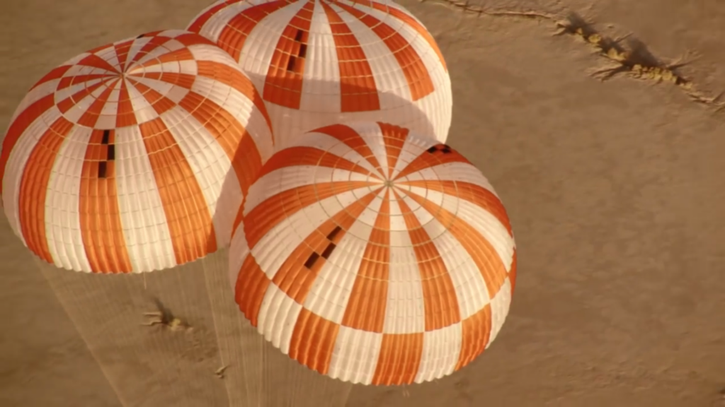
Practical applications for scientific imaging include observation of the flowfields of vehicles returning from deep space, documentation of heat shield integrity, verification of safety systems like in-flight aborts and parachutes, and much more. Many missions end with a capsule landing in the ocean, slowed by parachutes which then begin to sink. The infrared capabilities of SCIFLI’s optical systems help to recover these quickly, limiting environmental damages and preserving parachutes for analysis.
Most importantly, SCIFLI’s main goal is to ensure the safety of spaceflight. The team was created in the wake of the Columbia shuttle accident (link), and that memory continues to inspire the team to reduce risk in future flights.
Types of Imaging
One of the great strengths of SCIFLI is their multi-spectral approach to imaging. For missions that focus on documentation of flight safety systems such as in-flight aborts and parachutes, SCIFLI can collect data in the visual spectrum and hand this directly off to the customer. Infrared imagery may be the best option if the observation is taking place in low-light or hazy weather, conditions that can limit the quality of visual data. Paired with additional image processing, infrared data can also be used to extract the surface temperature of a vehicle. Spectroscopic imaging has been used to analyze high-speed returns such as the Hayabusa 2 mission. (link) Spectroscopy can be an incredibly useful tool for analyzing both the plasma environment around the spacecraft and the surface of the capsule as it enters the atmosphere, as well as any ablation to the thermal protection system from reentry.